Our Stretch of Route 50: What the Crash Records Show
For most of us, Route 50 is the only way to get anywhere. It carries commuters headed east toward Dulles and the Beltway, horse vans on their way to the shows, school buses, farm trucks, weekend cyclists, and, at dusk, deer. Everybody who lives out here has a story about a close call on it.
On October 18, a woman riding a bicycle near Briar Patch Lane, east of town, was struck by a passing horse trailer and critically injured. Since then, people around town and online have been arguing about one question: just how dangerous is this road?
The Eccentric went to the state's own records to find out.
About one crash a week
The Virginia Department of Transportation publishes every crash police report in the state, along with its counts of how many vehicles use each stretch of road. We pulled both for the 15.6 miles of Route 50 from the roundabout at Gilbert's Corner west through Upperville.
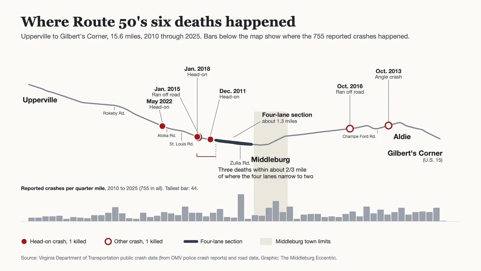
From 2010 through 2025, police were called to 755 crashes on that stretch. That is almost one a week, every week, for sixteen years.
Six people were killed. Forty-two more were seriously injured.
More than a quarter of the crashes involved an animal, and in recent years that has nearly always meant a deer. From 2017 through 2025, drivers hit a deer 108 times on this stretch, about once a month. The next most common crashes were rear-end collisions, 96, and vehicles leaving the road and hitting a tree, a fence or something else, 78.
Where people died
The six deaths were not spread evenly along the road.
Four happened west of the four-lane section past Zulla Road, on the two-lane road toward Upperville. Three of those were head-on collisions, in December 2011, January 2018 and May 2022. The fourth, in January 2015, was a vehicle that ran off the road.
Three of those four deaths happened close together, within about two-thirds of a mile west of the spot where the four lanes narrow back to two.
The other two happened on the Loudoun side, between Middleburg and Aldie: a collision at an angle in October 2013 and a vehicle that ran off the road in October 2016.
The police reports behind those records note what officers found at the scene: speed in two of the six crashes, alcohol in one, a distracted or drowsy driver in three, and an icy road in one. The public data does not say whether anyone was passing.
No one has been killed between Middleburg and Aldie since then. From 2017 through 2025, for the traffic each carries, serious injuries ran about four times as high on the two-lane road toward Upperville as on the road from Middleburg east to Aldie.
The four-lane stretch
Anyone who drives west out of town knows the spot. For about 1.3 miles past Middleburg's western town line, Route 50 suddenly opens up to four lanes, then squeezes back down to two.
Measured against the traffic it carries, that short section had the highest crash rate on the whole stretch from 2017 through 2025, about half again the rate elsewhere. No one was killed there in those years, and one person was seriously injured.
Where passing is allowed
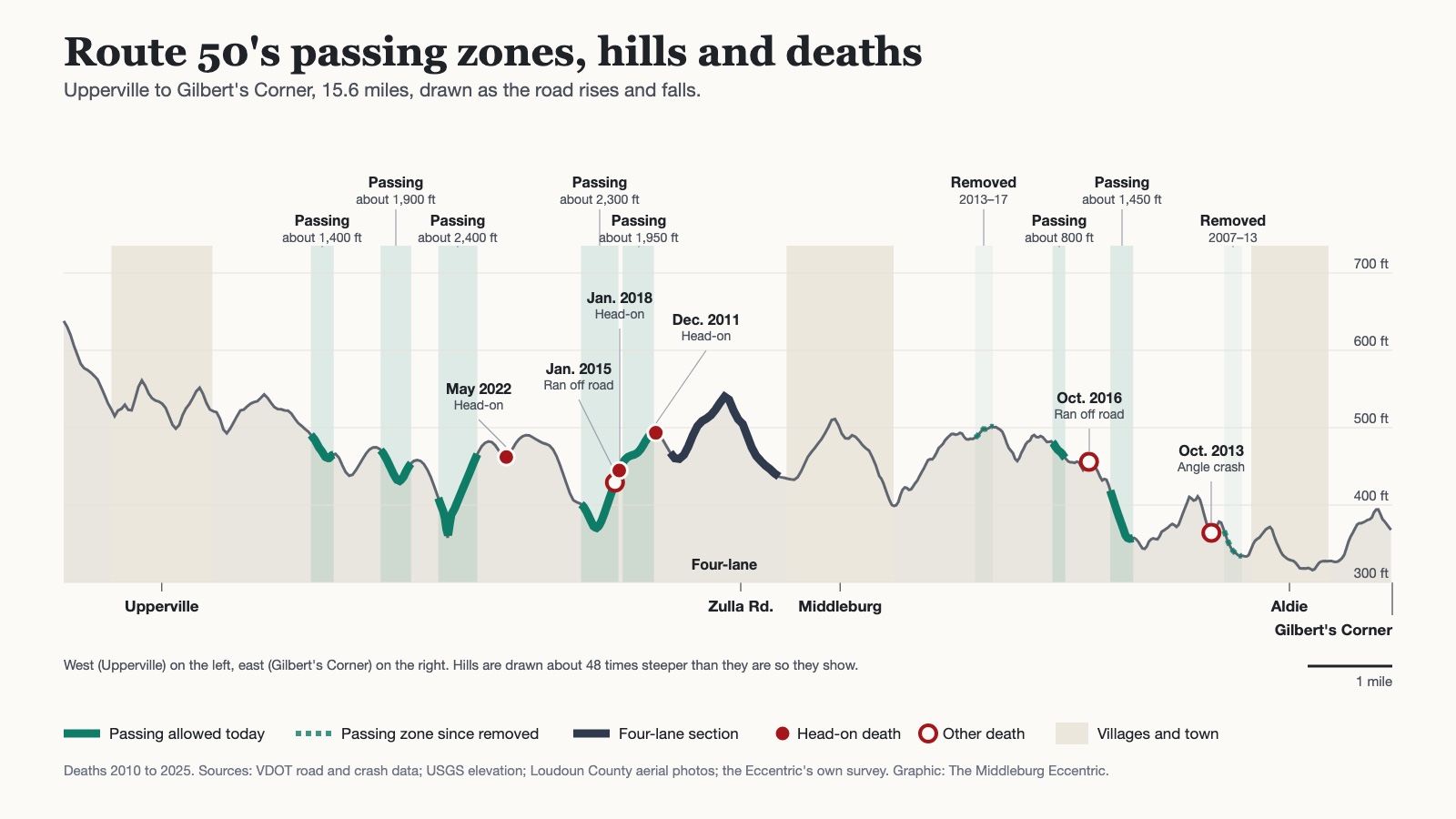
The Eccentric also mapped where the yellow lines allow passing. Seven passing zones remain on these 15.6 miles today, from a short one east of Middleburg to the longest, nearly a mile of broken line in two stretches just west of where the four lanes end. At least two others, both east of town, were painted out: one just west of Aldie, between 2007 and 2013, and one about a mile east of Middleburg, between 2013 and 2017.
The graphic below lays the passing zones over the road's hills. Two of the three head-on deaths happened at or just beyond the ends of the passing zones west of the four-lane section. The crash records give locations only to within a few hundred feet, and they do not say whether anyone was passing.
Cyclists
The October crash is not in the state's data yet; the public records run through early August 2026. According to a search-warrant filing reported by Loudoun Now, the horse trailer crossed the double yellow line to pass the rider and pulled back in too soon. The Sheriff's Office told the Eccentric on October 28 that no one had been charged.
In the sixteen years before that crash, two crashes on this stretch involved a bicycle, in 2016 and 2018, both east of Middleburg. Neither rider was seriously hurt.
Eleven days after the Route 50 crash, on October 29, a 72-year-old cyclist was killed when he was struck by a pickup truck at the intersection of Welbourne Road and St. Louis Road, north of Route 50. That crash was not on the road covered here.
Is it worse than other roads?
Traffic engineers compare roads by counting deaths for every 100 million miles driven, so a busy highway and a quiet country road can be measured fairly. VDOT counts between about 6,100 and 9,700 vehicles a day on different parts of this stretch.
From 2017 through 2025, this part of Route 50 had about 0.5 deaths per 100 million miles driven. Over the full sixteen years it was about 0.8. On the two-lane road toward Upperville alone, from 2017 through 2025, it was about 1.2. Nationwide in 2024 the rate was 1.19, according to the National Highway Traffic Safety Administration, and on rural roads it was 1.56. Virginia's was 1.05, according to the state Department of Motor Vehicles.
So by the usual measure, our stretch of Route 50 as a whole has been no deadlier than an ordinary road, and safer than most rural ones. The two-lane road toward Upperville is right about at the national average. But six deaths is a small number, a single crash moves a rate like this a long way, and none of that is much comfort to anyone who has come over a hill toward Upperville and found a car in their lane.
What the law says
Several readers asked whether bicycles are even allowed on Route 50. They are. Under Virginia law, a person riding a bicycle has the same rights and duties as the driver of a vehicle (Va. Code § 46.2-800).
A rider going slower than traffic must keep as far right as is safely practicable. Riders may ride two abreast, but they must not block traffic and must move into single file as soon as practicable when a faster vehicle comes up behind them (§ 46.2-905).
A driver passing a bicycle, a horse, or a horse-drawn vehicle must leave at least three feet, must not move back to the right until safely clear, and must change lanes if the lane is too narrow to pass with that room (§ 46.2-839).
What's planned
Loudoun County's transportation plan calls for a 10-foot shared-use path along one side of Route 50 from Everfield Drive to Willisville Road. In a 2025 Route 50 safety study, county staff worked out which side of the road the path should follow, section by section. The study also proposed taking the four-lane section west of Middleburg down to one lane in each direction.
The study's final report was expected in early 2026. It has not been posted on the county's study page, and the Eccentric found no record that the Board of Supervisors has acted on it.
Under the Virginia Freedom of Information Act, the Eccentric asked VDOT for its records on Route 50 passing zones and safety studies, and for crash records going back to 2010. VDOT released records on Nov. 16 and referred the crash-report request to the Department of Motor Vehicles, which the Eccentric has also asked. We have also sent VDOT written questions about the road, with answers requested by Nov. 24. We will report what they say.
How we did it: Crash records are from VDOT's public crash data, which republishes Virginia DMV crash reports; recent records are preliminary. Traffic counts are VDOT's 2022 annual average daily traffic, the most recent published, applied to every year, so rates for the earlier years are approximate. Rates are deaths or serious injuries divided by the miles driven on each section.